


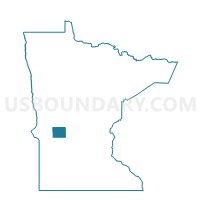
Nora Twp. Voting District, Pope County, Minnesota
About
Outline

Summary
| Unique Area Identifier | 603753 |
| Name | Nora Twp. Voting District |
| County | Pope County |
| State | Minnesota |
| Area (square miles) | 36.11 |
| Land Area (square miles) | 33.87 |
| Water Area (square miles) | 2.24 |
| % of Land Area | 93.81 |
| % of Water Area | 6.19 |
| Latitude of the Internal Point | 45.71591160 |
| Longtitude of the Internal Point | -95.69694110 |
Maps

Graphs
Select a template below for downloading or customizing gragh for Nora Twp. Voting District, Pope County, Minnesota


Neighbors
Neighoring Voting District (by Name) Neighboring Voting District on the Map
- Ben Wade Twp. Voting District, Pope County, MN
- Framnas Twp. Voting District, Stevens County, MN
- Holmes City Twp. Voting District, Douglas County, MN
- Land Twp. Voting District, Grant County, MN
- New Prairie Twp. Voting District, Pope County, MN
- Solem Twp. Voting District, Douglas County, MN
- Swan Lake Twp. Voting District, Stevens County, MN
- White Bear Lake Twp. Voting District, Pope County, MN
Top 10 Neighboring County Subdivision (by Population) Neighboring County Subdivision on the Map
- Holmes City township, Douglas County, MN (804)
- White Bear Lake township, Pope County, MN (431)
- Framnas township, Stevens County, MN (305)
- Land township, Grant County, MN (261)
- Ben Wade township, Pope County, MN (250)
- Solem township, Douglas County, MN (233)
- Nora township, Pope County, MN (205)
- New Prairie township, Pope County, MN (197)
- Swan Lake township, Stevens County, MN (194)
Top 10 Neighboring Unified School District (by Population) Neighboring Unified School District on the Map
- Minnewaska School District, MN (9,402)
- West Central Area Schools, MN (5,165)
- Cyrus Public School District, MN (721)
Top 10 Neighboring State Legislative District Lower Chamber (by Population) Neighboring State Legislative District Lower Chamber on the Map
Top 10 Neighboring State Legislative District Upper Chamber (by Population) Neighboring State Legislative District Upper Chamber on the Map
Top 10 Neighboring 111th Congressional District (by Population) Neighboring 111th Congressional District on the Map
Top 10 Neighboring Census Tract (by Population) Neighboring Census Tract on the Map
- Census Tract 4502, Douglas County, MN (3,769)
- Census Tract 4509, Douglas County, MN (3,509)
- Census Tract 702, Grant County, MN (2,926)
- Census Tract 9703, Pope County, MN (2,501)
- Census Tract 4801, Stevens County, MN (2,426)